Day Seven
National Great Rivers Museum 1
国立大河川博物館1
[Note] If this page is too small to be readable, please enlarge it to 120-125%. Thank you.
After visiting the Lincoln-Douglas Square, we drove to the East on the Great River Road to get to the National Great Rivers Museum. The Great River Road is kind of a
nickname for a few combined roads that run by the Mississippi River: State Highway 100, National Highway 67, and State Highway 143, called from west to east. We took 67 first, and then
drove on 143. About 10 minute drive took us to the museum. [1]As of October, 2013, the construction was on the way for making the the museum vicinity
a big river park. We parked our car at the parking lot closest to the museum entrance.
1.As of January, 2021, the construction has been over and a huge oblong levee area consists of a few big parking lots, a beautiful green levee mound, and
a comfortable bike road run on the mound as far as checked on the Google photo.
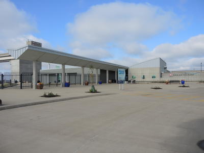
This photo shows the open space in front of the the museum entrance. A huge bare soil area spread on the river bank from the museum. Construction vehicles and some construction
workers could be spotted in that big area.
The museum stands by the left end of the Melvin Price Locks And Dam, which serves for the safety and easier sail of the boats that go up and down daily on the Mississippi River. Single
click on the photo for its enlargement.
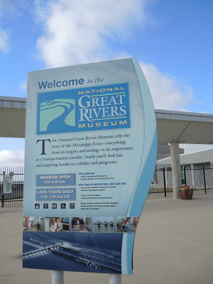
This is a description board that stands by the museum entrance. It explains the purpose of the museum, its open days and hours, and the hours of the Locks and Dam tour. The
museum tells us "the story of the Mississippi River -- everything from its origins and ecology to its importance as a transportation corridor." Single click for enlargement of the
photo.
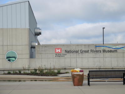
This photo shows the right end of the museum building. The logo of the US Army Corps of Engineers is placed on the top of the musuem name. This whole facility is managed and
maintained by that organization. Single click on the photo for its enlargement.
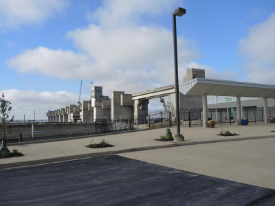
The photo shows the Melvin Price Locks And Dam as seen from the museum parking lot. What you see is its left-side part. The construction of it started in 1979 and was completed in
1994. Its anscestor was partly made of wooden materials and had long suffered serious safety problems. That made Melvin Price, the then U.S. Senator from Illinois, decide to work very hard for
the construction of a new, much stronger locks and dam. His huge contribution to the renovation is commemorated in the name of this facility.
By the way, do you know what lock means? It's a special gate through which boats can pass a dam. The Melvin Price Locks and Dam has two these locks, and that's why it's called
Locks and Dam. Single click on the photo for its enlargement.
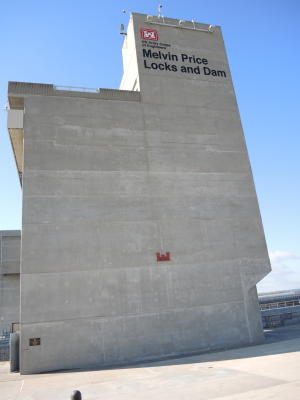
This big wall makes the left-side end of the Melvin Price Locks And Dam. It stands on the left bank of the Mississippi River and it can be seen from the museum terrace.
You may want to join in the dam tour, which is available for the public a few times a day. Single click on the photo for its enlargement.
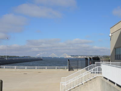
This photo shows the upstream stretch of the Mississippi River and the Clark Bridge crossing it, as seen from the museum yard.
The Clark Bridge is named after William Clark, one of the first explorers to reach the Pacific Ocean. They camped on the river bank several miles downstream, where they prepared for the
long journey to the Pacific Ocean through the Missouri River and beyond.
The bridge is famous because of its architectural beauty and the enormous difficulties that engineers faced while they built it against gigantic powers of the fast flowing
Mississippi River water. The big flood that occurred in 1993 was especially hazardous. It damaged many important parts of the bridge and the engineers almost gave up on continuing
its construction.
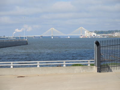
The Clark Bridge zoomed in. The right-hand bank in the photo is Alton, Illinois, whereas the left bank is the northern end of St. Louis, Missouri. The bridge is built in the cable-stayed-bridge format.
In this format the deck of a bridge is held with cables that are slantingly connected to one vertically elected stout tower. (The number of a tower can be multiple.) If the Clark Bridge had been longer, the so-called
suspension bridge format would have been chosen. In this latter format the deck is held with cables that are hung on one long cable that is horizontally crossed between two bridge towers, as is
typically seen on the Golden Gate Bridge in San Francisco.
Click on the photo for enlargement.
Day Seven continues to the next page.
七日目は次のページに続きます。
|


)
)
)
)
)
)
)